حقائق رئيسية
- المواعيد
- 15–19 فبراير 2027 (5 أيام)
- المكان
- Salana Boutique Hotel، فيينتيان، لاوس
- الرسوم لكل مشارك
- £3,420 (جنيه إسترليني)
- الدفع
- بالفاتورة والتحويل المصرفي
- إغلاق التسجيل
- 27 ديسمبر 2026
- الشهادة
- شهادة إتمام
- الخيار المؤسسي
- نفّذه لفريقك، في المواعيد التي تناسبك
نظرة عامة على البرنامج
Floods, landslides, storms and drought now hit the same districts more often and with higher costs. Preparedness agencies need to know where hazards will strike, what is exposed and how fast they can see the damage. GIS and Earth observation answer those questions at a speed field surveys cannot match.
Lao PDR shows why this matters. The post-disaster needs assessment for the 2018 floods put the total effects at about US$371.5 million across 55 districts in 13 provinces, after Tropical Storm Son-Tinh, the breach of a saddle dam at the Xe Pian-Xe Nam Noy hydropower scheme in Attapeu and Tropical Storm Bebinca. In September 2024, Typhoon Yagi brought floods to eight northern and central provinces and affected around 140,000 people, according to UNICEF’s first situation report.
Satellite data now reaches responders within days. After Yagi, Sentinel Asia was activated at the request of the ASEAN AHA Centre, and partner agencies produced flood maps from Sentinel-1, ALOS-2 and FORMOSAT-5 imagery. Their value depends on national teams that can validate and use them.
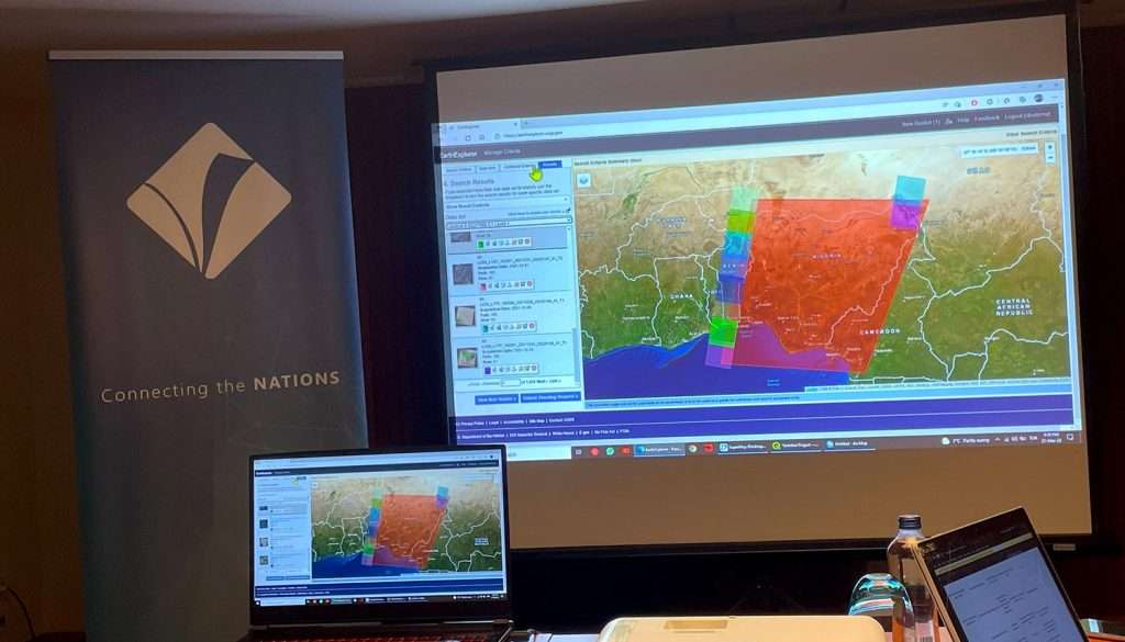
This five-day programme in Vientiane builds that capability. Participants work hands-on with open tools such as QGIS and cloud platforms such as Google Earth Engine, using free Copernicus Sentinel data, to produce hazard, exposure and vulnerability layers, risk maps, rapid damage assessments and products that feed early warning and recovery planning. Case material comes from real financed programmes in Lao PDR.
Risalat delivers the programme as a partner to disaster management committees, hydrometeorological services, line ministries, project implementation units and humanitarian organisations, helping teams turn data they already have access to into decisions they can defend.
يعزز البرنامج القدرات المؤسسية في
- Designing spatial data needs for disaster risk management
- Building national and provincial risk databases
- Hazard mapping for floods, landslides and storms
- Exposure mapping of buildings, roads and critical facilities
- Social and physical vulnerability assessment
- Spatial multi-criteria analysis for risk reduction planning
- Optical and radar satellite image processing
- Flood extent mapping with Sentinel-1 radar data
- Rapid damage and needs assessment after disasters
- Requesting and using international satellite activations
- Impact-based forecasting and early warning products
- Participatory GIS with communities and local authorities
- Spatial data infrastructure and data-sharing agreements
- Cost-benefit analysis of risk reduction options
- Risk information for recovery and reconstruction planning
- Monitoring and reporting against the Sendai Framework
Each skill is practised on real or realistic datasets, so participants leave with a working approach they can apply to their own provinces, river basins and projects.
- الجمع
- التنقية
- التخزين
- التحليل
- القرار
The Growing Importance of GIS-Based Disaster Risk Management
Financiers and governments are moving money from response towards prevention, and spatial risk information is the basis for that shift. In Lao PDR, the first World Bank Southeast Asia Disaster Risk Management Project (P160930), approved in 2017 with a US$30 million IDA credit and a US$1 million grant from the Southeast Asia Disaster Risk Insurance Facility trust fund, targeted flood impacts in Muang Xay and the government’s hydrometeorological and response capacity. Its successor, SEADRM II (P510690), was approved in May 2026 with a US$60 million IDA credit within a US$100 million total, covering urban flood protection, hydromet services, last-mile warning pilots and disaster risk insurance.
Early warning is the other driver. Writing for WMO in December 2025, the Department of Meteorology and Hydrology, now under the Ministry of Agriculture and Environment, set a 2027 goal of reliable, actionable warnings for at least 80 percent of the population, with more monitoring stations, an additional radar in the south and impact-based forecasts. It also notes that warnings are often tied to short-term projects and that last-mile access remains difficult. GIS is how impact-based forecasts link a rainfall threshold to the villages, schools and roads that will be affected.
تحتاج المؤسسات بشكل متزايد إلى مهنيين قادرين على:
- Specifying the spatial data a risk assessment actually needs
- Combining hazard, exposure and vulnerability into risk indices
- Running multi-criteria analysis to prioritise investments
- Producing maps that support impact-based forecasts
- Validating satellite products with field and community data
- Requesting Sentinel Asia or International Charter activations
- Estimating damage quickly for needs assessments
- Writing data-sharing protocols and metadata
- Presenting risk information clearly to senior officials
- Tracking progress against national and Sendai targets
Strong GIS-based risk management systems help organisations:
- Target flood protection and resilience works where risk is highest
- Issue warnings that tell people what will happen where
- Shorten the time from disaster to verified damage figures
- Justify budgets and financing requests with evidence
- Coordinate responders around a single operational picture
- Plan resettlement, land use and reconstruction with risk in mind
- Prepare credible inputs for disaster risk insurance and financing
- Report results to financiers and national committees
The legal framework supports this. Lao PDR’s Law on Disaster Management (No. 71/NA), adopted by the National Assembly in June 2019, calls for proactive risk management, accurate information and links with regional and international partners. Spatial analysis is how those principles become daily practice.
Who Should Attend This GIS and Remote Sensing for DRM Training?
صُمم هذا البرنامج من أجل:
- Officers of national and provincial disaster management committees
- Staff of meteorology and hydrology departments
- Flood forecasting and early warning specialists
- GIS and remote sensing officers in line ministries
- Urban planners and municipal engineers
- Water resources and river basin managers
- Public works and transport planners
- Project implementation unit staff on resilience projects
- أخصائيو الضمانات البيئية والاجتماعية
- Humanitarian and Red Cross / Red Crescent programme staff
- UN agency and NGO information management officers
- Insurance and disaster risk finance analysts
Basic computer literacy is expected. Prior GIS experience helps but is not required: exercises are paced so that beginners and experienced analysts both progress.
حدّد ما يحتاج فريقك إلى القدرة على إنجازه.
GIS and Remote Sensing for DRM Training Objectives
Upon successful completion of this GIS and Remote Sensing for DRM Training, participants will be able to:
- Assess the spatial data requirements of a disaster risk management task
- Set up a GIS project with correct coordinate systems and metadata
- Map hazards, elements at risk and vulnerability using GIS and remote sensing
- Apply spatial multi-criteria analysis to plan risk reduction measures
- Map flood extent from Sentinel-1 radar imagery
- Detect change from optical imagery for landslides and damage
- Use Google Earth Engine for rapid, large-area analysis
- Design GIS inputs for impact-based forecasting and early warning
- Run participatory mapping with communities and verify data in the field
- Produce rapid damage assessments that support recovery planning
- Evaluate data availability and the role of spatial data infrastructure
These objectives update the original course aims for hazard, vulnerability and risk assessment, early warning, participatory GIS and damage assessment, with current open data and cloud tools.
Source: World Bank (P160930, 2017) and SEADRM II project data (P510690, 2026)
1. Which satellite data type is most reliable for mapping floods under monsoon cloud cover?
Radar sees through cloud; after Typhoon Yagi in 2024, Sentinel Asia partners mapped Lao floods with Sentinel-1 and ALOS-2 radar data.
2. What were the estimated total effects of the 2018 floods in Lao PDR, according to the post-disaster needs assessment?
The 2018 PDNA put total damage and losses at about US$371.5 million across 55 districts in 13 provinces.
3. What population coverage target has Lao PDR's Early Warnings for All roadmap set for 2027?
The Department of Meteorology and Hydrology reported to WMO a goal of reliable, actionable warnings for at least 80 percent of the population by 2027.
محتوى البرنامج وهيكله
- Hazard, exposure, vulnerability and risk: terms and models
- Sendai Framework priorities and ASEAN regional arrangements
- Lao PDR’s 2019 Law on Disaster Management and committee structure
- Basic concepts of GIS and remote sensing for risk reduction
- Coordinate reference systems and data integration
- Global and national data sources for disaster risk
- Designing and setting up a GIS project in QGIS
- Flood hazard mapping from elevation and historical events
- Landslide susceptibility using slope, geology and land cover
- Mapping buildings, roads, schools and health facilities at risk
- Population and social vulnerability layers
- Spatial multi-criteria analysis: weighting and sensitivity
- Combining layers into composite risk indices
- Preparing spatial data in spreadsheets and joining to maps
- Optical and radar sensors: strengths and limits in monsoon conditions
- Copernicus Sentinel-1 and Sentinel-2 data access
- Radar flood mapping: thresholds, speckle and permanent water
- Change detection for landslides, erosion and damage
- Introduction to Google Earth Engine scripts
- Accuracy assessment and validation with ground data
- Visualising risk information in QGIS and SAGA
- The four components of people-centred early warning systems
- Early Warnings for All in Lao PDR: goals and reported gaps
- Impact-based forecasting: linking thresholds to exposed assets
- Regional flood forecasting along the Mekong
- Requesting Sentinel Asia, International Charter and UNOSAT support
- Mapping evacuation routes, shelters and displaced populations
- Participatory GIS with village authorities and volunteers
- Rapid damage assessment from satellite and drone imagery
- Post-disaster needs assessment: the role of spatial data
- Lessons from the 2018 floods and the Attapeu dam breach
- Risk-informed recovery and reconstruction planning
- Spatial data for disaster risk finance and insurance
- Spatial data infrastructure and inter-agency data sharing
- Dashboards and briefing maps for senior officials
المحتوى الكامل يوماً بيوم
The five days move from data foundations to hazard and risk mapping, satellite monitoring, early warning and response, and a final integrated exercise.
- Day 1: Risk concepts, frameworks and spatial data foundations
- Day 2: Hazard, exposure and vulnerability mapping
- Day 3: Satellite image processing and flood mapping
- Day 4: Early warning, response and participatory GIS
- Day 5: Damage assessment, recovery planning and capstone
المحتوى الكامل يوماً بيوم
First Day | Risk Concepts and Spatial Data Foundations
- Hazard, exposure, vulnerability and risk: terms and models
- Sendai Framework priorities and ASEAN regional arrangements
- Lao PDR’s 2019 Law on Disaster Management and committee structure
- Basic concepts of GIS and remote sensing for risk reduction
- Coordinate reference systems and data integration
- Global and national data sources for disaster risk
- Designing and setting up a GIS project in QGIS
- GPS and mobile GIS for field data capture
- Data quality, metadata and version control
Workshop: Building a Provincial Risk Geodatabase
Teams assemble a starter geodatabase for a flood-prone province using open boundaries, elevation, river networks, roads and settlement data. They define a common coordinate system, document metadata and identify the gaps that a national agency would need to fill before the data could support planning or warnings.
Second Day | Hazard, Exposure and Vulnerability Mapping
- Flood hazard mapping from elevation and historical events
- Landslide susceptibility using slope, geology and land cover
- Mapping buildings, roads, schools and health facilities at risk
- Population and social vulnerability layers
- Spatial multi-criteria analysis: weighting and sensitivity
- Combining layers into composite risk indices
- Preparing spatial data in spreadsheets and joining to maps
- Cost-benefit analysis of risk reduction options
- Using risk maps for land-use and investment screening
Workshop: Prioritising Flood Protection Investments
Using the design of the World Bank SEADRM projects as a reference, participants rank a set of candidate urban flood protection sites. They combine hazard, exposed assets and vulnerability, test different weightings and prepare a one-page justification that a project implementation unit could put before its steering committee.
Third Day | Satellite Image Processing and Flood Mapping
- Optical and radar sensors: strengths and limits in monsoon conditions
- Copernicus Sentinel-1 and Sentinel-2 data access
- Radar flood mapping: thresholds, speckle and permanent water
- Change detection for landslides, erosion and damage
- Introduction to Google Earth Engine scripts
- Accuracy assessment and validation with ground data
- Visualising risk information in QGIS and SAGA
- Producing map products for emergency operations
- Archiving products for later recovery analysis
Case Study: Typhoon Yagi Floods, September 2024
Participants examine the Sentinel Asia activation for northern Lao PDR, when partner agencies supplied Sentinel-1 and ALOS-2 based flood maps within days. Teams reproduce a flood extent map from open Sentinel-1 data, compare it with the published products and discuss how a national team would validate and use them.
Fourth Day | Early Warning, Response and Participatory GIS
- The four components of people-centred early warning systems
- Early Warnings for All in Lao PDR: goals and reported gaps
- Impact-based forecasting: linking thresholds to exposed assets
- Regional flood forecasting along the Mekong
- Requesting Sentinel Asia, International Charter and UNOSAT support
- Mapping evacuation routes, shelters and displaced populations
- Participatory GIS with village authorities and volunteers
- Last-mile dissemination channels and local languages
- Google Maps and Earth for situational awareness
Workshop: Designing an Impact-Based Warning Map
Teams take a river basin forecast scenario and build an impact map showing which villages, schools, roads and health facilities would be affected at different water levels. They draft the warning message for each level and set out how it would reach remote communities, reflecting the last-mile challenges reported by the Department of Meteorology and Hydrology.
Fifth Day | Damage Assessment and Recovery Planning
- Rapid damage assessment from satellite and drone imagery
- Post-disaster needs assessment: the role of spatial data
- Lessons from the 2018 floods and the Attapeu dam breach
- Risk-informed recovery and reconstruction planning
- Spatial data for disaster risk finance and insurance
- Spatial data infrastructure and inter-agency data sharing
- Dashboards and briefing maps for senior officials
- Sustaining GIS capacity after projects close
- Individual action plans for participants’ institutions
Capstone Exercise: From Flash Flood to Recovery Plan
Drawing on the 2018 Attapeu flash flood, which UN-SPIDER also used as the basis of a national simulation in 2019, teams run the full cycle: map the flood from imagery, estimate damaged assets, brief a disaster committee with a short map pack and outline a risk-informed recovery plan. Each team presents and receives structured feedback.
GIS and Remote Sensing for DRM Training Methodology
The programme is computer-based and practical. Every participant works on their own laptop with open-source software and free data, so the methods can be repeated at home without licence costs.
يجمع البرنامج بين:
- Short expert briefings on concepts and frameworks
- Guided step-by-step exercises in QGIS
- Cloud-based exercises in Google Earth Engine
- Work with real Sentinel-1 and Sentinel-2 imagery
- Case studies from Lao PDR and the wider Mekong region
- Group workshops built around financed projects
- Scenario simulations of flood events
- Field data collection with mobile GIS
- Peer review of maps and analyses
- Individual coaching during exercises
- ملخص يومي واختبارات للمعارف
- Action planning for each participant’s institution
Participants receive the datasets, scripts and templates used in class.
- المدخلات
- الأنشطة
- المخرجات
- النتائج
- الأثر
الزيارات الفنية والبرنامج الميداني
Where available, the programme includes a technical visit linked to hydrometeorological monitoring, satellite data reception or disaster management operations in Vientiane. Visits are confirmed with host organisations closer to the programme dates, and the content of the day is adjusted so that participants still complete the practical exercises if a visit cannot take place.
النتائج المتوقعة
Upon completion of this GIS and Remote Sensing for DRM Training, participants will be able to:
- Build and maintain a risk geodatabase for their area
- Produce hazard, exposure and risk maps to a documented standard
- Map flood extent from radar imagery within hours of data release
- Use satellite change detection to support damage assessment
- Contribute GIS inputs to impact-based warnings
- Run participatory mapping exercises with communities
- Brief decision-makers with clear, accurate map products
- Prepare an action plan to embed GIS in their organisation’s routines
The combined result is a team that can move from raw data to a decision-ready product without waiting for outside support.
£3,420 لكل مشارك · فاتورة وتحويل مصرفي · خصم للمجموعات المكوّنة من 5 مشاركين أو أكثر
خمسة مشاركين أو أكثر من مؤسسة واحدة: اطلبوا سعر المجموعة عند طلب الفاتورة.
Ten or more: an in-house version for your institution may cost less per person. Ask for an in-house quote.
Registration closes in 55 days (27 Dec 2026)
Institutional Application of GIS and Remote Sensing for DRM Training
يدعم هذا البرنامج المؤسسات في تعزيز:
- National and provincial risk information systems
- Hydrometeorological and early warning services
- Disaster preparedness and contingency planning
- Post-disaster needs assessment capacity
- Risk screening of infrastructure investments
- Urban flood risk management
- Data sharing between ministries and agencies
- Disaster risk finance and insurance preparation
- Reporting to financiers and national committees
- Community-based disaster risk management
يعود المشاركون بأدوات عملية لتحسين:
- Geodatabase templates and metadata standards
- Flood mapping workflows for radar data
- Multi-criteria analysis models
- Impact-based warning map templates
- Rapid damage assessment checklists
- Satellite activation request guidance
- Participatory mapping field guides
- Briefing map and dashboard layouts
Institutions that want to check their starting point can use Risalat’s free digital readiness assessment or the institutional capacity assessment before nominating staff.
الأهمية الإقليمية والتطبيق
آسيا
Southeast Asia combines monsoon floods, typhoons and landslides with fast-growing infrastructure. Regional mechanisms such as the AHA Centre and Sentinel Asia already deliver satellite products during emergencies, as the September 2024 activation for Lao PDR showed, so the main gain for national agencies is the ability to request, validate and use those products quickly.
أفريقيا
Many African agencies face recurrent floods and drought with limited ground monitoring. Free satellite data and cloud processing let small teams map events and exposure across large territories.
الشرق الأوسط
Flash floods in arid catchments, drought and urban drainage failures are growing concerns. Elevation analysis, rainfall data and change detection support zoning, drainage planning and early warning in fast-growing cities.
المحيط الهادئ
Small island states face cyclones and coastal flooding with small technical teams; open-source GIS keeps exposure data current and supports rapid post-cyclone assessment.
Europe and Latin America
European agencies use the Copernicus programme operationally for emergency mapping, offering a useful model of how a satellite service connects to civil protection. Latin American countries facing floods, landslides and earthquakes use similar tools for risk-informed land-use planning.
Across regions, the common need is the same: national teams that turn open data into risk information that planners, forecasters and responders trust.
Host Country Profile – Laos
Vientiane, the capital of Lao PDR, sits on the Mekong River and is home to the national ministries, the Department of Meteorology and Hydrology, development partners and the National University of Laos. It is a calm, compact city that suits focused technical training, and it was itself among the areas affected by the 2018 floods and by flooding in September 2024.
Lao PDR is a strong learning case for spatial risk management. It has a recent legal framework for disaster management, two generations of World Bank disaster risk management projects, an Early Warnings for All roadmap supported by the CREWS initiative, and a volunteer geospatial community, LaoNGUM, established in 2016 with UN-SPIDER support. Participants see how a country with mountainous terrain, major rivers and growing hydropower is building warning and risk information systems step by step.
Vientiane is served by Wattay International Airport with regional connections. Many nationalities can obtain an e-visa or a visa on arrival, but rules differ by passport, so participants should confirm requirements with the nearest Lao embassy or official government portal. Risalat provides visa support letters and guidance after registration. The dry season, from about November to April, is generally the most comfortable time to travel.
GIS and Remote Sensing for DRM Training Deliverables
Every participant receives a full package of materials, tools and support, before, during and after the programme.
قبل البرنامج
- التقييم المسبق للمشاركين
- Disaster Risk GIS Readiness Assessment
- Disaster Risk GIS Resource Pack
- مواد قراءة تحضيرية
- دعم واستشارات مجانية بشأن التأشيرة
- الاستقبال من المطار والمساعدة عند الوصول
- إقامة مع الإفطار
- عشاء ترحيبي للتعارف
أثناء البرنامج
- حقيبة Risalat التدريبية (حقيبة، وقارورة، وكوب، وقميص، وقبعة، وغلاف جواز سفر، وأقلام، ودفتر، ومغناطيس وميدالية مفاتيح)
- Comprehensive Disaster Risk GIS Training Manual
- Risk Geodatabase Template
- Sentinel-1 Flood Mapping Workflow
- Google Earth Engine Script Library
- Multi-Criteria Analysis Model
- Impact-Based Warning Map Template
- Rapid Damage Assessment Checklist
- ورش عمل عملية ومحاكاة
- مناقشات جماعية وتعلم من الأقران
- غداء ومرطبات يومية
- الاستفادة الكاملة من مرافق مكان التدريب
- جهاز Mini Pad / جهاز لوحي مزود بمواد تعليمية رقمية
- زيارة ميدانية (حسب الاقتضاء)
- جولة ترفيهية في المدينة
بعد البرنامج
- شهادة الإتمام
- جائزة Risalat تقديراً للمشاركة في البرنامج
- مواد مرجعية بعد التدريب
- Open Dataset Directory for Disaster Risk
- Satellite Activation Request Guide
- Institutional GIS Action Plan Template
- الدعم بعد التدريب وإرشادات المتابعة
- تقرير البرنامج
Ministries, disaster management committees and project implementation units can request a tailored in-house version of this programme using their own data and provinces. Please use the request a proposal form to tell us about your team and objectives.
Common Challenges in GIS-Based Disaster Risk Management, And How This Training Helps
How can agencies build risk maps when national data is incomplete?
Day 1 shows how to combine open global datasets with national layers, document gaps and set quality rules, so teams can start useful work now and improve the data over time.
How can cloud cover during the monsoon be overcome for flood mapping?
Day 3 focuses on Sentinel-1 radar, which sees through cloud, with practical thresholds, validation and the handling of permanent water bodies.
How can international satellite products be used quickly and correctly?
Day 4 explains how Sentinel Asia, the International Charter and UNOSAT are requested, and Day 3 trains participants to validate external maps against local data before use.
How can forecasts be turned into warnings that people act on?
The Day 4 impact-based warning workshop links forecast thresholds to exposed villages and assets and addresses last-mile dissemination and local languages.
How can investment priorities be justified to financiers and committees?
Day 2 covers multi-criteria analysis and cost-benefit analysis, using the design of the SEADRM projects to show how evidence supports funding decisions.
How can damage figures be produced fast enough for recovery planning?
Day 5 covers rapid damage assessment from imagery and the spatial inputs to a post-disaster needs assessment, using the 2018 floods as a case.
How can GIS skills be kept when donor-funded projects end?
Day 5 addresses data infrastructure, shared geodatabases and institutional action plans so that skills and data stay inside the organisation.
الأسئلة الشائعة
Do I need GIS experience to join?
No. Basic computer skills are enough. Exercises are guided step by step, and experienced analysts get extension tasks.
Which software is used?
Mainly open-source and free tools: QGIS, SAGA and Google Earth Engine, with free Copernicus Sentinel data, so participants can repeat the work without licence costs.
هل ينبغي أن أحضر حاسوباً محمولاً؟
Yes. Please bring a laptop with administrator rights so that software can be installed. Setup instructions are sent before the programme.
Is the content specific to Laos?
Case studies come from Lao PDR and the Mekong region, but the methods apply anywhere and participants can work on data from their own country.
هل يمكن تقديم البرنامج داخل المؤسسة؟
Yes. Risalat can tailor it to an institution's own provinces, data and systems and deliver it at a location of the client's choice.
جميع البرامج في فيينتيانالمزيد من برامج تغير المناخ والبيئة
لماذا فيينتيان لهذا البرنامج
وقع الاختيار على فيينتيان (لاوس) لهذا البرنامج لسهولة وصول المشاركين المتوقعين إليها وتوافر أماكن ملائمة للتدريب العملي والتفاعلي.
The Disaster Risk Management GIS & Remote Sensing Training in Vientiane programme in February 2027 brings together officials and professionals. Sessions combine short inputs, case studies and group work on participants' own files, and the city's institutions can be added as a study visit on request.
تحقق مما إذا كنت بحاجة إلى تأشيرة عبر أداة التحقق من التأشيرة المجانية، واطلب خطاب دعوة بعد إتمام تسجيلك.
الموضوع نفسه في مدن أخرى
- برنامج تدريبي في إدارة المخاطر البيئية والاجتماعية لإعادة الإعمار بعد الفيضانات في إسطنبول (إسطنبول)
- برنامج تدريبي في الحماية الاجتماعية الرقمية: الحماية الاجتماعية المدعومة بالذكاء الاصطناعي وإدارة الحالات المتكاملة (لشبونة)
- برنامج بناء القدرات في المخاطر المناخية والأمن الصحي (مانيلا)
- برنامج تدريبي في تقييم المخاطر البيئية وإدارتها والتواصل بشأنها (ويلينغتون)
- برنامج تدريبي في الإدارة المتكاملة للموارد المائية وتغير المناخ والتكيف (فيينتيان)
- برنامج تدريبي في إدارة مخاطر الفيضانات والقدرة على الصمود المناخي والتكيف مع الفيضانات الحضرية (طوكيو)
المزيد من الدورات التدريبية في لاوس · جميع البرامج في آسيا · تقويم التدريب الكامل